
Historical
Preservation
Precision & Efficiency with LiDAR Scanning
A Comprehensive Digital Documentation Approach
Line & Circle delivers services to preserve historic sites while using modern reality-capturing systems. We bring together modern technology with historical research to create better approaches in architectural preservation beyond its typical ways of recording history
Our Comprehensive Workflow
We take a series of established steps to gather high-quality data, make precise adjustments,
while preparing the information for future historic protection.
Phase 1: Data Acquisition
Precision and Discovery
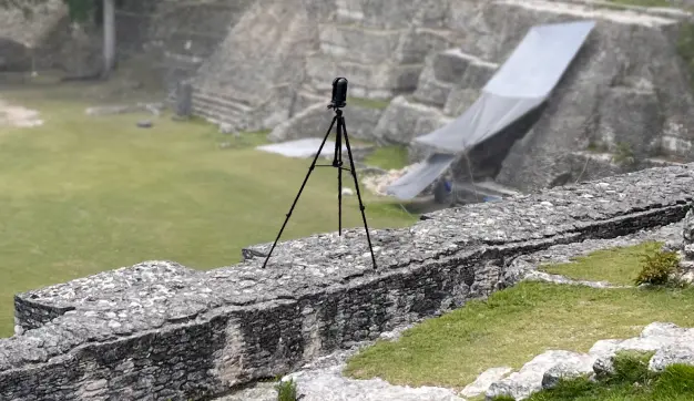
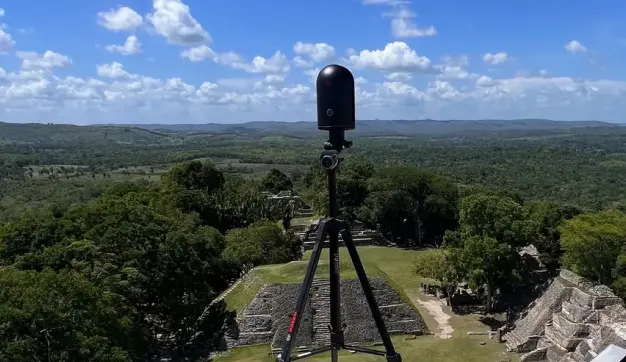
Reality Capturing Techniques
The documentation process starts by using top-tier data collecting methods to measure every aspect of ancient buildings during documentation:
- LIDAR Scanning: Our scanners use lasers to create exact 3D maps of buildings and site locations at a millimeter scale.
- Photogrammetry: We capture high-quality pictures, which advanced computers convert into three-dimensional precise models.
- Investigative Fieldwork: We observe buildings at their actual locations and check historical records during the research process. A complete assessment of the site takes place before the scanning workload begins. This historical research helps to understand the building’s special story from its historical context.
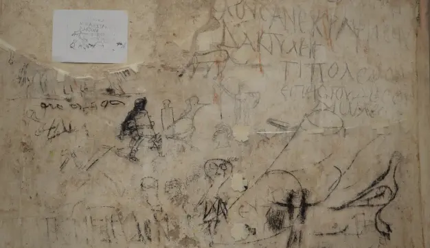
Historical Research
We go beyond just measuring external characteristics; we uncover the story behind each structure. Knowing the life events of buildings helps us preserve them correctly. Our research process includes:
- Archival Research – Studying original construction techniques, materials, and past modifications.
- Keeping records of the materials used for building as well as document the building methods.
- We detect prior restorations and previous modifications found in the historical records.
- Inventory Sheet Preparation – We use collected data to build a standardized document system for easy information tracking.
Phase 2: Data Processing
Making Information Accessible
Metadata Management
Our team turns unorganized scanning results into easily readable digital files.
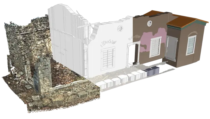
- Point Cloud Generation: The software builds a complete 3D model using actual measurement results. The method creates exact scale records of the historic structure that help designers and analysts work together.
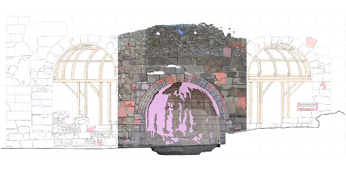
- Orthophoto Creation: The tool produces 2.5D digital data that supplies exact distance readings and shows surface features in detail. The method creates full architectural and conservation research results.
- 3D Surface Modeling: This essentially translates to a 3D modeling process using industry standard NURBS and mesh modeling techniques from the information stored in point cloud data. It guarantees highest geometric accuracy and most detail preservation.
Condition Assessment
Effective restoration requires evaluating a structure’s current state. Our assessment process includes:
Phase 3: Management
Future-Proofing Architectural Heritage
Documentation Strategies
We create multi-dimensional digital records that capture both tangible and intangible heritage:
- As-found state documentation is used to document the current and past conditions of a building.
- In-situ analysis revealing explicit and implicit historical information.
- Development of preservation strategy on the basis of detailed digital documentation.

Scan-to-BIM and Digital Twin Creation
Real world scan data is translated to an interactive Building Information Modeling (BIM) platforms:
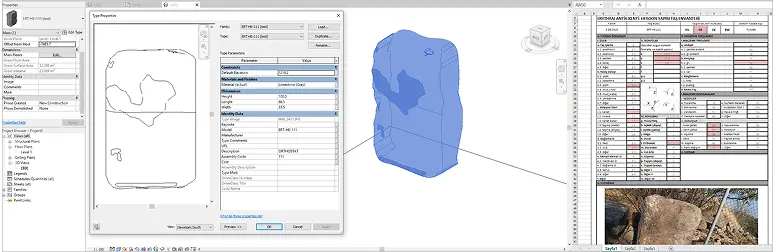
- HBIM Implementation – Converting 3D scans into Historical Building Information Models (HBIM) for documentation and analysis.
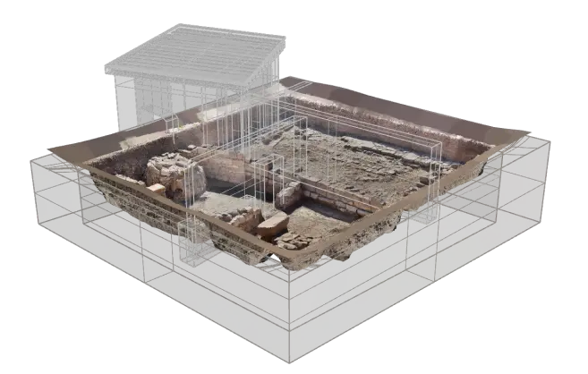
- Semantic 3D Models – Logically represented, interactive 3D models of the captured environment based on research and analysis.
- Enabling advanced monitoring, management, and conservation planning.
Phase 4: Curation
Bringing History To Life
Digital Dissemination
Our approach makes historical documentation engaging and accessible:
Immersive 3D modeling for professional and public engagement.
- Virtual restoration and reconstruction techniques.
- Interactive 3D annotations for researchers and preservation specialists.
- Compelling visual narratives that communicate architectural history.
Archival & Visualization
We provide advanced visualization tools for researchers and conservationists:
- Architectural Visualization (ArchViz) – Producing photo-realistic renderings of historic sites.
- Immersive Solutions – Enabling interactive site exploration through virtual reality.
- Animation & Storytelling – Developing visual narratives that enhance research and public appreciation.
Frequently Asked Questions
What is HBIM?
Historic Building Information Modeling (HBIM) is a specialized BIM application. Unlike 3D modeling, HBIM incorporates retaining, identifying, and maintaining detailed building information about materials, features, construction techniques, historical changes, and preservation work management in industry-standard BIM platforms
What is a Digital Twin?
A digital twin is a highly detailed virtual replica of a physical structure that can be used for analysis, monitoring, and preservation planning. It goes beyond simple 3D representation by integrating real-time data, historical information, and predictive modeling capabilities.
How does LIDAR scanning help in historic preservation?
LIDAR scanning captures high-resolution, precise 3D data of historic buildings. This data is used for documentation, structural analysis, and virtual reconstruction.
What is Scan-to-BIM?
The Scan-to-BIM process is to implement 3D laser scan raw-data into a Building Information Model platform. This technique allows for exact digital documentation, capturing even the most minute architectural details.
Why Choose Line & Circle?
Our commitment to accuracy, innovation, and preservation makes us a leader in the field. Here’s what sets us apart:
1. Expertise in HBIM and Digital Twins
We specialize in Historical Building Information Modeling (HBIM) and Digital Twin technology, allowing for detailed 3D representations and ongoing monitoring of historic structures.
2. Advanced 3D Scanning Technologies
Using LIDAR, photogrammetry, and high-resolution imaging, we ensure unparalleled accuracy in digital documentation.
3. Tailored Preservation Strategies
Our approach integrates historical research, condition assessment, and 3D modeling to create customized conservation plans.
4. User-Friendly Digital Deliverables
We provide structured, accessible digital models that can be used for research, restoration planning, and public engagement.
We don’t just document buildings; we preserve their stories, ensuring that architectural heritage remains vivid, understood, and protected for future generations.