
Reality Capture
Services
Precision & Efficiency with LiDAR Scanning
Ditch The Tape Measure. Upgrade To Reality Capture.
At Line & Circle, we use cutting-edge LiDAR 3D scanning technology to deliver precise, high-quality, and scalable reality capture services — eliminating the guesswork and inefficiencies of traditional methods.
At Line & Circle, we use cutting-edge LiDAR 3D scanning technology to deliver precise, high-quality, and scalable reality capture services — eliminating the guesswork and inefficiencies of traditional methods.
LiDAR vs. Traditional Photogrammetry
LiDAR is not photogrammetry. It’s a far more accurate and reliable way to capture real-world measurements.
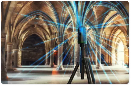
One of the primary methods of LiDAR is terrestrial laser scanning, which is highly effective for precise ground-based data collection. Industries such as archaeology, construction, and geospatial mapping utilize this technique to achieve more accurate measurements.
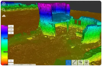
LiDAR provides precise measurements with real-world colors in a 3D file known as a point cloud. LiDAR is not photogrammetry, although they share similar approach in the reality capturing realm, the technology is different. Photogrammetry, in basic terms refers to overlapping images taken by a camera which then be processed into point cloud. Unlike Photogrammetry, which relies on extra equipment to scale and orient the images taken of the object(s), LiDAR provide locally united and scaled measurements which are produced by laser beams not only images, therefore, the resulting data differs than image-based data acquisition -photogrammetry. Although they both give point cloud data after processing the acquisition; LiDAR based point clouds are denser and have higher level of detail.

How It Works
- Unmatched Accuracy – LiDAR captures data accurate to 1/8″, providing reliable as-built conditions.
- Terrestrial LiDAR Scanning – We use tripod-mounted and ground-based scanners, moving them throughout the site to ensure complete coverage.
- Point Cloud Processing – Once scanning is complete, the data is transferred to a central computer, where it is stitched together into a single, cohesive file.
- Seamless Software Integration – The final point cloud file is compatible with Revit, AutoCAD, and other drafting software, ensuring seamless integration into your workflow
Why Choose LiDAR?
- Higher Accuracy As-Built Scans – Reduce errors and costly rework.
- Efficient & Fast – No more back-and-forth site visits or missing measurements.
- Complete Project Coverage – Extract precise plans, elevations, sections, and models.
LiDAR provides a high-accuracy foundation for any project, giving you a seamless and efficient starting point for drafting, modeling, and construction.
LIDAR Benefits for AEC Industry:
Accurate As-Built Documentation
LiDAR captures geometric data in millimetre precision, far beyond the accuracy achievable with traditional measuring tapes or even laser distance meters.
Reliable Measurements, Faster Results
LiDAR scanning captures comprehensive 3D data in hours or days, whereas conventional methods take weeks and are prone to measurement inconsistencies. It is also nearly impossible to measure or capture the amount of data that the scanner can pick up.


Eliminates Rework
With LiDAR-generated datasets, teams can detect clashes between MEP, structural, and architectural elements before construction begins, preventing costly rework and delays, eliminating the time required for costly Construction Administration costs, resubmittals, and RFIs.
Enhanced Site Safety
LiDAR scanning requires minimal time on-site, is non-invasive, and also reduces the need for personnel to enter hazardous areas, unlike manual measurement methods that expose workers to risks.
Versatility Across Industries
LiDAR scanning companies like Line & Circle offer flexible solutions that can be used in many fields, whether you work in architecture, engineering, construction, AEC or any other field that needs accurate measurements. For a wide range of uses, our reality capture services are perfect, such as:
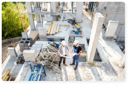
Construction and Renovation
Photograph the building as it currently stands to ensure your design aligns with the existing structure, preventing costly mistakes and additional work.
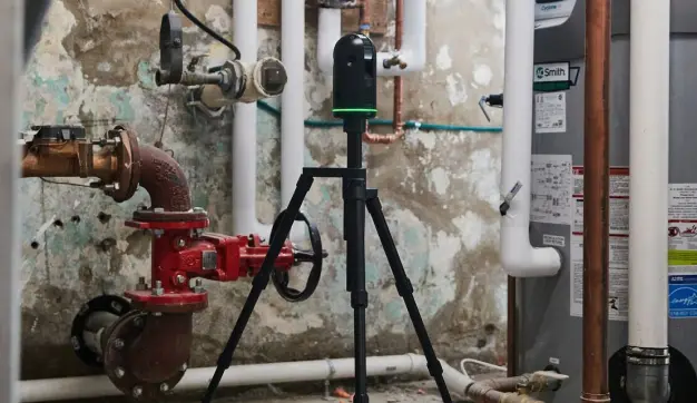
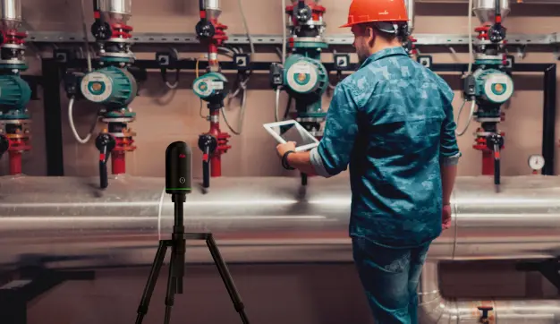
Industrial Facilities
Create a map and examine complex systems such as pipes, electrical wiring, or machines to ensure you have accurate information for repairs and upgrades.
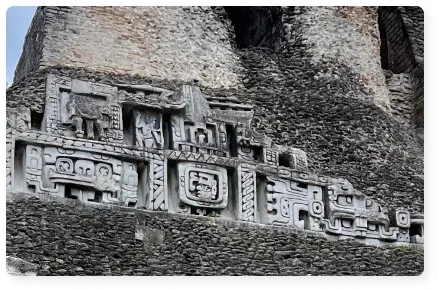
Historic Preservation
Make accurate 3D recordings of historic buildings or places to help with documentation and preservation work.

Environmental Monitoring
Gather information about the land’s shape and environment for purposes such as urban planning, environmental studies, or land surveys.

Oil and Gas
Thoroughly check company buildings, pipelines, and other infrastructure to ensure they are safe and up to code.

Simulation & Reverse Engineering
Create multi model digital representation of built environment from interior to exterior with high level of detail for monitoring, energy simulation and resiliency.

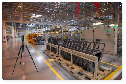
Manufacturing
Take advantage of having CAM-ready 3D surface models via high fidelity, high level of detail 3D geometric measurements.
Real Estate
Whether to rent or sell a place real-time immersive walkthrough of a property is provided with LiDAR scanning.
Forensics
Enable precise digital documentation, ensuring accurate calculations for insurance assessments and loss estimation and damage evaluation for insurance claims.
How Does Our LiDAR Scanning Work?
LiDAR 3D scanning utilizes laser beams to determine the distance to various surfaces, creating a “point cloud” of data that accurately represents the space from interior to exterior. A LiDAR 3D scanner emits thousands of laser pulses every second. These pulses strike objects and return to the scanner. By measuring the time it takes for each pulse to come back, the scanner can calculate the distance to each object. This process enables the creation of precise digital representation of surface geometry in 3D of the environment.

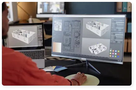
3D laser scanning services provide fast and precise data acquisition of large areas. Once the data is collected, it can be processed to create highly detailed point cloud data. Point cloud, which refers to millions of points that each have separate X, Y, Z values with RGB information (for color). Point clouds can then be imported into software such as BIM platforms like Revit, CAD environments like AutoCAD, and 3D modelling software i.e. Rhinoceros3D and Blender.
Terrestrial laser scanning (TLS) is a precise LiDAR technology that captures detailed 3D data of landscapes and structures from a fixed position. It works by emitting laser pulses that reflect off surfaces, measuring their return time to calculate distances and generate a point cloud. Industries like construction, archaeology, and geospatial mapping use TLS for its high accuracy, non-contact data capture, and broad applications.
Our team at Line & Circle handles the whole process, from gathering data to sending you valuable metadata like point clouds and orthophotos in the format of your choice. We do everything related to LiDAR scanning, from setting it up to collecting data, processing it, and ensuring you can use it. This way, you can ensure you get the most accurate and helpful information possible.
High-Quality Visuals and Data
3D scanning with LiDAR gives you accurate measurements and high-quality rectified images without perspective distortion, orthophotos that show how things are in the real world when you add HD texture overlays. This can be especially helpful for projects that care a lot about how things look, like design, repair, or restoration. Having high quality orthophotos is beneficial to have accurate and scaled condition assessment of a specific wall or surface of the project. Which can be implemented to different phases of AEC industry from aesthetic design options to have detailed estimation on specific material loss or deterioration.

How Accurate Data Improves Project Outcomes
Benefits of Our LiDAR Scanning Services

Precision in Every Detail
We use cutting-edge LiDAR scanning technology to create highly accurate 3D measurements models that show every detail of your project from inside and out. Our lidar scanning services ensure that you have a complete and accurate picture of the room, including architectural features like doors and windows and engineering features like mechanical, electrical and plumbing designs, MEP. LiDAR utilization provides budget management and estimation of any design project from bidding to just kitchen renovating fast and accurately.

Better Accuracy with TLS
As a key component of our advanced LiDAR solutions, we utilize terrestrial laser scanning (TLS) to deliver high-definition, ground-based 3D scans with exceptional accuracy. TLS is highly effective for site analysis, precise structural documentation, and historical preservation, ensuring accurate measurements for even the most complex projects.

Seamless Integration with Existing Software
You can easily import the data you get from our laser scanning services into the drawing and design software you already have, such as BIM platforms , CAD, and other 3D modelling platforms. This makes adding LiDAR scanning services to your work easy and saves time because you don’t have to measure or make changes by hand.

Monitoring and Simulation
LiDAR scanner derived point clouds can be utilized to have digital twins of the built environment. That is possible with BIM implementation from reality capture, scan-to-BIM workflow. With the help of correct 3D digital representation of the built environment, you can simulate energy efficiency, structural movement (with periodic LiDAR scanning) and strategic management of the property.
Why Line & Circle?
Line & Circle is one of the best LiDAR scanning companies, dedicated to offering new, accurate, and quick LiDAR scanning services. Our team of skilled experts will ensure that you get the most out of our 3D laser scanning services by providing accurate data that is simple to add to your existing processes.
As a leader in cutting-edge solutions, Line & Circle excels in terrestrial laser scanning (TLS). From structural analysis and high-resolution site documentation to historical preservation, we provide unmatched precision and clarity. Our advanced TLS strategies ensure accurate data at every step, empowering you to make informed, data-driven decisions with complete confidence in the results. For us, quality, dependability, and happy customers are the most important things. We work closely with you to ensure that our services fit the specific needs of your project. When you use our LiDAR scanning services, you can get the accurate, up-to-date information you need to ensure the success of any project, no matter how big or small from interior to exterior

Get Started with Line & Circle
Are you ready to move on from the inefficient old way of measuring and into the future of building and design with LiDAR scanning services? Contact Line & Circle immediately to learn more about our LiDAR 3D scanning, laser scanning, and reality capture services. We can help you take a clear, quick, and accurate picture of your project.